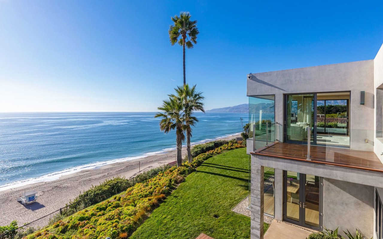
An oceanfront address in Malibu is rare. Entitlements are rarer. If you are eyeing a beachfront or blufftop lot, the rules, studies, and timelines can shape whether you can build the home you imagine. This guide explains how Malibu’s coastal rules work, the key site tests to run, and the practical steps to de‑risk your path before you commit. Let’s dive in.
Malibu’s coastal rulebook
Malibu sits entirely within California’s coastal zone. Local review is governed by the City’s certified Local Coastal Program, which sets detailed standards for setbacks, uses, and permitting. Start with the City’s LCP overview and procedures on the Local Coastal Program page and the Planning Department portal.
The California Coastal Commission applies statewide Coastal Act policies and can hear appeals in designated “appealable areas.” Projects must address coastal resources, public access, and hazards, including sea level rise. For technical approach and policy context, review the Commission’s Sea-Level Rise Policy Guidance.
Most oceanfront development needs a Coastal Development Permit. Expect discretionary review, public noticing, and the possibility of appeal to the Coastal Commission if the parcel lies in an appealable zone.
Core site constraints to test first
Bluff setbacks and geology
On blufftop lots, Malibu’s rules require setbacks that protect a 100‑year economic life with a 1.5 geologic safety factor. In many cases the minimum bluff setback is 100 feet, with limited potential reduction to 50 feet if supported by City geologic review. The exact line is driven by site-specific geotechnical work. See the LCP’s bluff setback standard in the municipal code.
Sea level rise and hazards
Your application must evaluate coastal hazards over time, including bluff retreat, wave run-up, and flooding under mid-century and end-of-century scenarios. The methodology and expectations are outlined in the Coastal Commission’s Sea-Level Rise Policy Guidance. Plan on integrating adaptive design or relocation options where warranted.
Flood zones and elevation
Check FEMA Flood Insurance Rate Maps for flood zones and Base Flood Elevation. These designations affect foundation design, finished-floor elevations, and insurance. Pull a parcel-specific map at FEMA’s Map Service Center.
Wastewater and utilities
If the site is not on sewer, you will need to confirm feasibility for an onsite wastewater treatment system. New OWTS installations require a coastal permit, and septic components must meet bluff and coastal setback rules. Review the City’s OWTS process early.
Biology and cultural resources
Oceanfront parcels can trigger biological and cultural surveys. Expect to screen for sensitive habitat and protected species and to avoid or mitigate impacts as part of your permit strategy.
Public access and the mean high tide line
The public has rights seaward of the mean high tide line. Ownership of dry sand above that line is fact-specific and can involve historic surveys and title research. For legal context, see this California case on public trust tidelands and access disputes involving the mean high tide line (case summary).
Shoreline protection reality check
New hard shoreline armoring is generally disfavored because it can accelerate beach loss. Approvals, if granted, are exceptional, time-limited, and heavily conditioned, with a strong preference for alternatives like relocation. Recent Commission actions underscore this trend (coverage of armoring decisions).
Your entitlement pathway
- Coastal Development Permit. Most new construction, major rebuilds, septic systems, subdivisions, and shoreline protection require a CDP processed under the LCP. Start with City checklists and pre-application guidance on the Planning Department site.
- CEQA review. Because CDPs are discretionary, environmental review often applies. Outcomes range from exemptions to Mitigated Negative Declarations and, for complex cases, full EIRs. Local CEQA procedures are referenced in the municipal code.
- Appeals. If your site is in an appealable area, a City decision can be appealed to the California Coastal Commission. Build schedule and design flexibility to navigate this stage.
Timeline and cost drivers
Complex oceanfront CDPs in Malibu commonly span 12 to 24 months from pre-application through hearings, with appeals extending the process. The City’s rebuild guidance offers practical examples of timeframes and fees (rebuild overview).
Key cost categories include:
- Technical studies: geotechnical and CEG reports, bluff retreat and slope stability, biological and cultural surveys, hydrology and flood analysis.
- Planning and permit fees: City application fees, noticing, and potential mitigation costs.
- Design, engineering, and surveying.
- Mitigation and public benefit conditions that may be required by the permit.
- Potential appeal-related or legal costs.
Buyer due diligence checklist
Run these items before you remove contingencies or commit to a building program:
- Title report and easements. Confirm any recorded public access easements or private rights-of-way.
- Prior permits and code history. Request all coastal permits, approvals, or enforcement records from the City.
- LCP zoning and appeal status. Pull a City parcel printout and confirm if the lot is in an appealable zone through the application portal.
- FEMA flood data. Generate a FIRMette and confirm Base Flood Elevation at the FEMA Map Service Center.
- Survey and shoreline data. Commission boundary and topographic surveys. For upland beach frontage, consider a mean high tide line or meander line inquiry, aligned with the public trust framework.
- Geotechnical screening. Engage a licensed geologist or geotechnical engineer for bluff retreat and stability feasibility.
- OWTS or sewer status. Verify sewer availability or start an OWTS feasibility review using the City’s OWTS guidance.
- Coastal hazards memo. Screen for sea level rise, wave run-up, and erosion consistent with state guidance.
Early go or no-go signals
- The required bluff setback places the footprint off the lot or into an impractical location per the LCP standard.
- A need for shoreline armoring appears likely, yet new armoring is disfavored or time-limited (recent precedent).
- The parcel lies in a flood zone that forces costly elevation and design changes per FEMA mapping.
- OWTS is infeasible within required setbacks, and sewer access is not available per the City’s OWTS process.
- Documented ESHA, significant visual impacts, or public access constraints that will be difficult to avoid under LCP and Coastal Act policies.
Navigate with a Malibu-native approach
High-value coastal decisions deserve local precision. As a Malibu native with a track record on oceanfront and bluff estates, I help you assemble the right technical team, sequence due diligence, and position your design to align with the LCP and Commission expectations. From pre-offer feasibility through hearings and closing, my role is to protect your time and outcomes while respecting privacy and presentation.
If you are considering an oceanfront acquisition or a new build, let’s talk about your goals and a clear path forward. Connect with Cooper Mount to get started.
FAQs
How do Malibu’s bluff setbacks work for oceanfront lots?
- Malibu typically requires a setback that protects a 100-year economic life with a 1.5 geologic safety factor, with a common minimum of 100 feet and limited reductions only with City geologic support, per the municipal code.
Do I need a Coastal Development Permit and how long could it take?
- Most oceanfront projects require a CDP, and complex permits often take 12 to 24 months including studies, hearings, and possible appeals, according to the City’s rebuild guidance.
Can I rely on a seawall to protect a new home?
- New shoreline armoring is generally disfavored, with approvals rare, heavily conditioned, and sometimes time-limited, reflecting the Commission’s approach highlighted in recent armoring decisions.
How does the mean high tide line affect beach access and ownership?
- The public has rights seaward of the mean high tide line, while upland dry sand can be private depending on surveys and title; disputes often reference case law like this California decision.
Which agencies and resources should I consult first?
- Start with the City’s Local Coastal Program page, the Planning Department’s guidance, FEMA’s map center, and the Coastal Commission’s Sea-Level Rise Policy Guidance.